Settings
Shipping Country
Languages
- Products description
- Reviews
- Manufacturer Information
Products description
Navionics, vector chart + 44XG for the Baltic Sea, Finland, Sweden on SD or CF memory cards has been around since 1983 and has since become one of the most widely used chart standards, especially for use on chart plotters. A new feature is the ability to use the charts with a special Navionics memory card reader with PC programmes such as the VISTANAUT software. This requires the original Navionics memory card reader. This device is a simple card reader and also decrypts the Navionics vector cards on the memory chips.
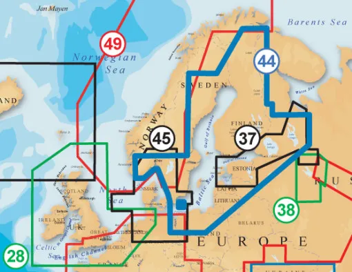
Coverage of the 44XG:
Baltic Sea except west of the Copenhagen - Rostock line, Gulf of Bothnia, Gulf of Finland, Lakes Ladoga and Onega, Lake Peipsi, Berlin Lakes. Sweden including the lakes, southern Norway to Flekkefjord. Finnish lakes inc. Inarijarvi, Porttipahdan Tekojarvi, Lokan Tekojarvi, Miekojarvi, Emijarvi, Vahonselka, Mourujarvi, Yli Kitka, Kiantajarvi, Vuokkijarvi, Oulujarvi, Nuasjarvi, Ontojarvi, Lentua, Pielinen, Koitere, Hoytiainen, Viinijarvi, Pyhaselka, Orivesi, Puruvesi, Pihlajavesi, Haukivesi, Kallavesi, Suvasvesi, Juojarvi, Puula, Kyyvesi, Onkivesi, Pyhajarvi near Sortavala town, Saimaa, Puruvesi, Pihlajavesi, Peilavesi, Nilakka, Pyhajarvi near Iisalmi town, Konnevesi, Kolima, Kivijarvi, Keitele, Paijanne, Vuohijarvi, Langelmavesi, Vanajavesi, Lappajarvi, Pyhajarvi near Rauma town, Lohjanjarvi-Vihti.
Plotter:
Raymarine, Furuno, Garmin, Eagle, Humminbird, Geonav, Lowrance, Northstar, PC (Vistanaut)
Chart type (no guarantee):
SD- Card (Eagle, Furuno, Lowrance, Murphy, Humminbird, Geonav G3)
This Product was added to our catalogue on 11/06/2009.
Customer reviews
Average rating: 0
Based on 0 Customer reviews
Write the first review please!
Manufacturer Information
Responsible Person: Michael Schwab, Döbelner Str. 12, 04741 Roßwein
Kontakt: https://js-maritimshop.de/Kontakt:_:7.html
Kontakt: https://js-maritimshop.de/Kontakt:_:7.html
Contact Manufacturer
JS Maritimshop & BootsserviceMichael Schwab
Döbelner Str. 12
04741 ROSSWEIN
GERMANY
info@js-maritimshop.de
Contact EU responsible person
JS Maritimshop & BootsserviceMichael Schwab
Döbelner Str. 12
04741 ROSSWEIN
GERMANY
info@js-maritimshop.de
This product goes perfectly with:
Last viewed


