Settings
Shipping Country
Languages
- Products description
- Reviews
- Manufacturer Information
Products description
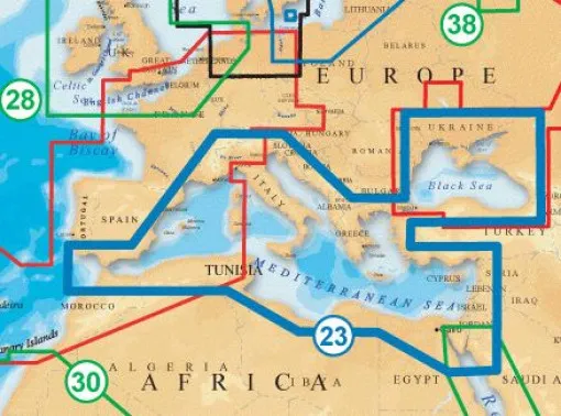
The + XL9 Navionics vector charts on SD or CF memory cards for the entire Mediterranean and Black Sea. These charts have since developed into one of the most widely used chart standards, especially for use on chart plotters, and can now also be used with PC programmes such as the VISTANAUT software using a special Navionics memory card reader. This requires the original Navionics memory card reader. This device is a simple card reader and also decrypts the Navionics vector cards on the memory chips.
Coverage of the 43XG: Mediterranean, Black Sea, Suez Canal, northern Red Sea
Plotter: Raymarine, Furuno, Garmin, Eagle, Humminbird, Geonav, Lowrance, Northstar, PC (Vistanaut)
Chart type (without guarantee): SD card (Eagle, Furuno, Lowrance, Murphy, Humminbird, Geonav G3)
Coverage of the 43XG: Mediterranean, Black Sea, Suez Canal, northern Red Sea
Plotter: Raymarine, Furuno, Garmin, Eagle, Humminbird, Geonav, Lowrance, Northstar, PC (Vistanaut)
Chart type (without guarantee): SD card (Eagle, Furuno, Lowrance, Murphy, Humminbird, Geonav G3)
This Product was added to our catalogue on 11/06/2009.
Customer reviews
Average rating: 0
Based on 0 Customer reviews
Write the first review please!
Manufacturer Information
Responsible Person: Michael Schwab, Döbelner Str. 12, 04741 Roßwein
Kontakt: https://js-maritimshop.de/Kontakt:_:7.html
Kontakt: https://js-maritimshop.de/Kontakt:_:7.html
Contact Manufacturer
JS Maritimshop & BootsserviceMichael Schwab
Döbelner Str. 12
04741 ROSSWEIN
GERMANY
info@js-maritimshop.de
Contact EU responsible person
JS Maritimshop & BootsserviceMichael Schwab
Döbelner Str. 12
04741 ROSSWEIN
GERMANY
info@js-maritimshop.de
This product goes perfectly with:
Last viewed


